
The following description of Sway is extracted, with a few amendments, from the Sway Village Design Statement, a supplementary Planning Document written for and by the people of Sway in 2013. Some information in the VDS and reproduced here was taken from "Sway From A to Z" with the kind permission of the author Tony Blakeley.
History of Sway
Sway is a settlement of Anglo Saxon origin. Its name, from the Old English name "Svieia", means "noisy stream" which is thought to be a reference to the Avon Water. However various spellings followed and it has also been suggested that Sway comes from another Old English word "swaeth" meaning a track through the forest.
Sway is listed four times in the Domesday Book of 1086. One such reference refers to a manor named Arnwood which has since been destroyed by fire; and a second refers to the earliest recorded building in Sway: Flexford Mill, which can still be seen today.
In 1543 at the time of the dissolution of the monasteries there were three manors of Sway known as Sway Romsey, Sway Quarr and Sway Christchurch. All the manors, although keeping their separate identities, came under one lord. An ancient custom allowed tenants of Sway Romsey to take wood for house repairs, making carts, ploughs and barns and for firewood.
The Enclosure Act of Sway Quarr, Sway Romsey and Arnewood of 1811 was of some importance to the village. Commissioners apportioned the previous common and waste lands which included King and Hyde Commons, Kettle Thorns, Arnwood Common, Downton Common, North Common and Sway Common. Some of this land lay between what is now Middle Road (Sway) and the Forest and to the side of what is now Station Road and in all covered some 684 acres. In 1820 the newly enclosed land was fenced and new roads laid. Soon cottages appeared where before there had been none and the centre of the village began to shift from Durns Town to its present location.
In 1817 Rev Henry Comyn, curate of Boldre, surveyed the parish. He found that the western part was a cluster of hamlets, including Pitmore, North Sway, Durns Town and Mead End, without any definable centre. St Luke's Church was built in 1839 on what is now Church Lane, and was followed by the creation of the ecclesiastical parish of Sway 1841. The civil parish of Sway was formed in 1879, when 2 ,200 acres (8.9 km2) were taken from the extensive parish of Boldre.
The earliest record of a school is 1838 when there was a Dame School in Manchester Road. Sway National School was then built in 1844 and around 1877 that was replaced by the Victorian building now referred to as the old school house. In 1985 the school moved into a new building in Westbeams Road. The old school house is currently occupied by the Wood Burning Centre although plans exist to demolish/replace it with 5 new dwellings.
The railway came to Sway in 1888, when Sway railway station was built. The majority of services arrived in Sway in the early to mid 20th century with mains water connected in 1930, electricity in 1932, gas in 1938 and mains sewerage in 1959.
In 1868 Andrew Peterson purchased a property in Barrows Lane known as Drumduan. He altered the building to develop a mansion, incorporating a small tower on the site and used concrete for much of the building. He later built Sway Tower, 66 metres (200 ft) tall which is now a Grade II* listed building. Its design is constructed entirely out of mass concrete made with Portland cement. It remains the tallest non-reinforced concrete structure in the world. The tower is visible from much of the New Forest.
Transport
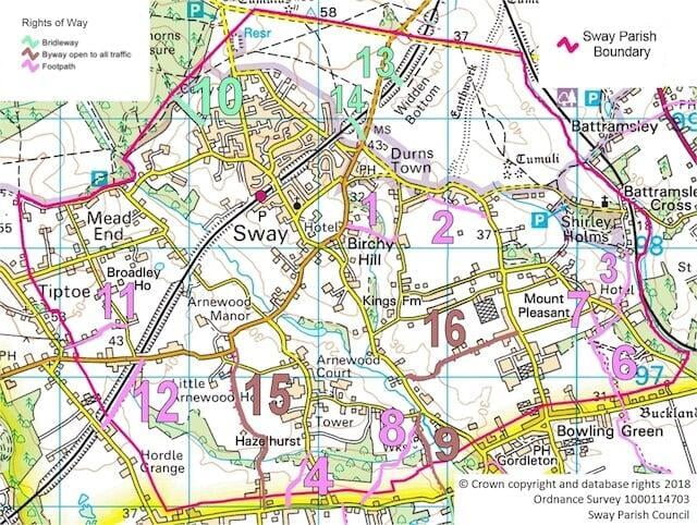
Sway is served by a well-used railway station providing a vital link to the mainline stations between London Waterloo and Weymouth. The line runs through the centre of the village predominately in a cutting in a northeast - southwest direction, with residential housing and the school playing fields adjacent to it. There are a number of bridges constructed from red brick to accommodate the line. In addition to the numerous minor roads the parish is bisected by the busy B3055 New Milton to Brockenhurst road situated to the south of the village centre. Within the village the main roads are Station/Brighton Roads, Manchester Road and Middle Road.
There are short sections of pavements on either side of the road between Meadens Garage and The Hare and Hounds public house, from the corner of Station Road and Birchy Hill up to Birchy Hill Nursing Home, and along Station Road leading into the village centre.
Although pavements can be found in some of the residential roads in the village there are no pavements along Brighton Road or Manchester Road; and many of the minor roads in the surrounding parish do not have pavements either. The majority of the residents consider that the lack of pavements reflects Sway's character.
Some areas are frequently congested with parked vehicles on roads and public verges and often block pedestrian access on pavements. There is no public car park in the centre of the village.
There are few road markings on Sway's roads. There are no yellow lines at all and the only restricted parking is in Westbeams Road where there is a zigzag area adjacent to the school entrance and In Jubilee Close where you will find a short extent of double yellow lines.
The village is served by a Cango bus which provides vital links to those residents that require the use of public transport to nearby towns of New Milton and Lymington. Select here to download a leaflet about Cango Cango Users Leaflet. A number of school buses pass through the village providing an important link to local secondary schools..
There are nine cattle grids separating the Open Forest from the main residential areas. These can be found on Brighton Road, Manchester Road, Durnstown, Back Lane, Pitmore Lane, Coombe Lane, Boundway, Marley Mount and Shirley Holms.
Economy
Many businesses are found in Sway, not only in the centre of the village but spread throughout the parish; and between them they offer a wide range of services. There are approximately fifty such enterprises which vary considerably in size from single proprietors to those that employ dozens of people. They provide much needed employment in the parish and are considered to be a vital element in keeping the village vibrant and working.
There are currently about ten retail outlets in the centre of the village, including a general store & post office, convenience store,, butchers, hairdressers, pharmacy and deli. In addition there are two estate agents, some industrial units and a few further business establishments in the wider parish beyond the defined local shopping frontage. The village is served by one public house, one restaurant and two hotels: The Manor at Sway in the centre of the village and Passford House Hotel in the outlying parish. The pub and hotels have their own car parks. The local shops provide a vital service especially appreciated by the elderly and those who rely on public transport. A further new convenience store is expected on the new development in the centre of the village (the former site of Hatch Motors).
Community facilities
The numerous and diverse community facilities are one of the defining factors that residents have highlighted in what makes Sway special.
Education: St Luke's CE Primary School situated off Westbeams Road is well attended by the children of the village. It has large playing fields and currently provides an after school club on site. Select here to visit the Primary School website.
Religion: St Luke's church provides regular services and social contact via the use of the church rooms. Select here to visit the Church website.
Community buildings: SpudWorks (formerly ArtSway) sited in the centre of the village; its use is currently under discussion. Sway Village Hall off Middle Road and the Youth Centre on Station Road both provide the community with a wide range of well used facilities for all age groups and include meeting rooms for clubs and societies, playgroups and a large stage and associated lighting used by the local drama group. The scout hut is a well-used building and is tucked away off Badgers Close. Jubilee Field Pavilion and sports ground is a major asset for the village. The Parish Council purchased the land during the 1990's. Fund raising and voluntary effort resulted in the building of a pavilion, a children's playground and excellent sports facilities including football, cricket and tennis. A cricket pavilion sits adjacent to the cricket field.
Public open space and land use by clubs:
Stanford Rise Green, an informal piece of public open space adjacent to the Village Hall, was previously laid mainly to grass. In recent years, investment via S106 funds and the NFNPA funded a joint project for a wild play installation and natural wood seating around the site. The Parish Council has planted fruit trees and a wild flower meadow, creating a tranquil, natural setting for family fun and games in the centre of the village.
The Memorial Field (football pitch on the open forest) at Pitmore Lane is well used by the under 13's to under 16's junior football teams during the winter months. The land was gifted to the parish following WW1 and is permanently open to the forest stock who keep the grass naturally cut.
Sway Bowmen Shooting Grounds off North Common Lane was established in 1985, as a Target Archery Club within the New Forest National Park and also has access to private woodland. They will soon commence building of their new club house, having successfully raised the funds to cover the development.
Allotments - The allotment site comprising of over eighty plots at Pitmore Lane is leased from the Forestry Commission in conjunction with the Verderers. Mains water is provided and the lots are let as full or half-plots. Due to their popularity there is usually an extensive waiting list.
Landscape Character and Land Uses
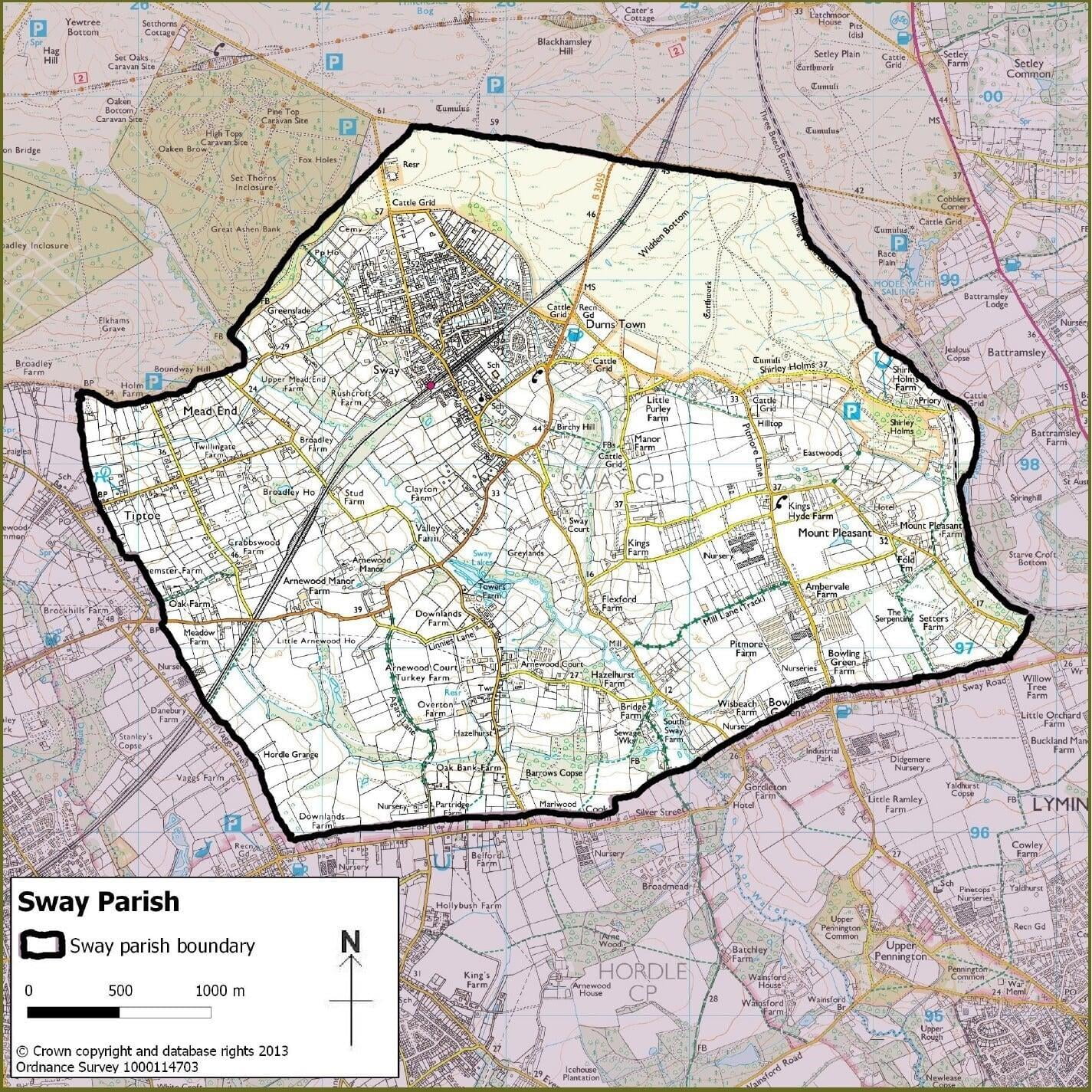
Sway Civil Parish consists of some 1321 hectares (3263 acres) at the southern edge of the New Forest, entirely within the New Forest National Park, and sufficiently inland to have no strong maritime influences. The land is mostly thin topsoil over clay, and there are two main stream-valleys running through the parish down towards the sea. Some 8% of the area is less than 20m above sea level - mostly in the valley of the Avon Water and those areas can be particularly water-logged. However because of the clay much of the parish has poor drainage and therefore includes a network of ditches and small brooks.
Lowland grassland dominates the rural scene. In terms of land usage the parish may conveniently be considered as three different areas: the Open Forest, the Defined Village and the remainder - the Outer Parish.
The Open Forest comprises about 19% of the land area, mostly in the north of the Parish. Most of that is open heathland or wet heathland, with some broadleaved woodland and only a minor portion is tree plantation. Because of the wetter ground Sway Open Forest contains some notable lowland fen, marsh and swamp and dwarf shrub heath.
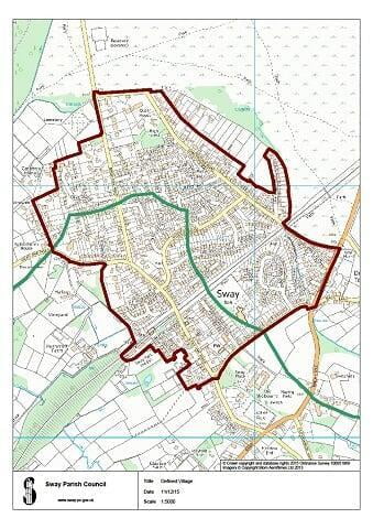
The Defined Village covers only some 6% of the land area, but the large majority of the population of the Parish reside here. It is dominated by residential property and curtilage, accompanying infrastructure and also contains almost all the recreational space. The land of this large but quiet village is now almost entirely built upon. The Defined Village lies towards the north of the Parish, close to the Open Forest.
The Outer Parish covering the remaining three quarters of the parish area is dominated by grassland (pasture and meadow) predominantly used for recreational horse-keeping. It includes a significant portion of agriculture and woodland as well as residential property and infrastructure. Rolling grassland, fencing, managed ditches and hedges and occasional buildings, sometimes in clusters, can be seen; with minor roads connecting them. Part of the village of Tiptoe is in the western end of the parish (the majority of Tiptoe coming under Hordle Parish.)
In addition to the Open Forest area, the Outer Parish includes a number of designated areas. There are two lowland acid grassland Sites of Special Scientific Interest: at Lower Mead End Farm and Fir Tree Farm. In addition, there are Six Sites of Importance for Nature Conservation (SINCs), being Barrows Copse, Hollow Wood, Silver Street Wood, Hordle Grange Wood, Passford Water and Switchells Wood - a number of which have rights of way passing through them or alongside. The Sway Tower Conservation Area was the subject of a comprehensive Character Appraisal report by the National Park Authority in March 2010 and everyone with land and/or property within that area should be aware of the special characteristics of the area.
The designated areas cover a larger area than the defined village and adding in the remainder of the Open Forest means that more than 20% of the area of Sway has an additional level of protection.
Settlement pattern and character
Following the Enclosure Act of 1811 and the building of the railway station in 1888 the Defined Village shifted from Durns Town to an area between Manchester Road, Brighton Road/Station Road and Church Road.
This area sits to the north of the parish, on the edge of the Open Forest and was developed piecemeal as the majority of the fields were sold off to developers during the 20th century. This has led to the main settlements of Sway having a broad mixture of property not only in style but also in size; however most properties sit within generous plot sizes.
Further roads lead off the centre of the village to individual houses and farms with properties varying in size from substantial detached buildings in large plots and small holdings to smaller bungalows and detached housing.
Other groups of development can be found in Pauls Lane and Kings Lane with the majority of housing consisting of 1960s and 1970s smaller detached properties within long thin plots and dormer bungalows and mixed housing on the west side of Pitmore Lane between Kings Lane and Sway Road.

